 .
.
Detailed description
.
.
SurGe consists of two basic programs files:
-
front end windows GUI program SurGe.exe (written in C)
-
console program SURGEF.EXE (written in FORTRAN)
SurGe.exe enables:
-
to read files containing input objects
(points, faults, polylines and / or boundaries) and to display them in graphical
window
-
to transform (rotate and so on) coordinates of input objects (points, faults,
polylines, boundaries)
-
to select parameters for interpolation / approximation and to run
SURGEF.EXE
-
to define filter for input data (points
XYZ)
-
to display raster color map or
3D view of resulting surface
-
to display shadowed color map or
shadowed 3D view
-
to compute isolines and display them
-
to compute and display gradient lines
-
to blank grid outside the boundary
-
to perform some mathematical calculations with surfaces
-
using mouse and keyboard to digitize points, faults, polylines, boundaries
and isolines
-
to define and display cross-sections
through several surfaces
-
to read and write grid files compatible with Surfer (in ASCII format)
-
to write grid files in GRASS and ArcGIS ASCII format.
-
using special procedures (see SurGe
Tutorial) to solve special tasks such as
-
wedging out of layers
-
preserving extrapolation trend in areas without data
-
direct conversion of seismic reflection times into the structural depth of
layer boundary
-
creation of layer thickness maps and volume calculation
SURGEF.EXE has the following features:
-
Implements the method ABOS (Approximation Based On
Smoothing). The ABOS is method for approximation (interpolation)
of z-coordinates of irregularly spaced points XYZ by continuous function
of two independent variables. Despite of the fact, there is
approximation in the name of the method, ABOS can also provide exact
interpolation. Description of the ABOS is in the
User's manual.
-
Number of input points is limited only by available computer memory.
-
In addition to the points XYZ, spatial polylines can be used as an input
to define surface shape.
-
Thanks to the interface enabling full control of the program, SURGEF.EXE
can be called as an interpolation engine from any user application.
-
The program creates a matrix of real numbers, which represents surface at
nodes of a grid. The number of the matrix elements is limited only by available
memory, but with respect to an acceptable time of computation, a reasonable
maximal number of nodes is about 6000000. It means that the maximal reasonable
"resolution" of resulting map can be for example 3000 x 2000 (in such
case the map with the size 3 x 2 meter will have the resolution 1 millimeter).
Return to the main page.
Graphical representation of input objects

Display of isolines

Raster color map

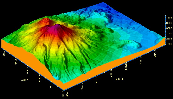
3D view

Shadowed color map

3D view of shadowed surface
Cross-section through four surfaces

Surface of unfiltered data
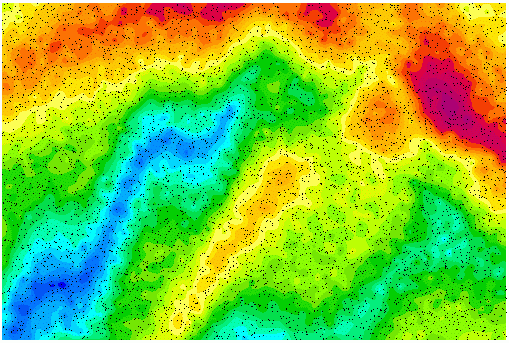
Surface of filtered data

Return to main page.